HF_MAP Sky Wave propagation
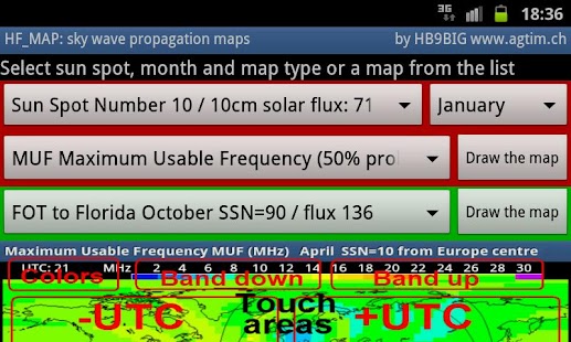
HF_MAP a graphical view to sky-wave propagation (short-wave 1-30MHz):Each map is build for a constant location and display the frequency to use to reach any other radio station worldwide.There is a map for each hour of the day; the values are mean values of the selected month for the specified solar activity.A 24-hour map set is more than 5000 point to point diagrams at once. The color scale steps are 2MHz.You can view the variation during the day by touching the map, left side for -utc, right side for +utc. Depending on your device the changes are very quick Continent outline, sun position and the gray-line (transition between day and night) are displayed over the color map.This let you observe how the frequency changes are related to the sun.There are 5 different palettes for the used scale, for the 3-colour palette you can shift the band selection high and low.See the screen shot of the touch areas on how to switch palettes. Selection in the red background area of the main screen:Solar activity, month, map type and the draw the map button.Constant location about Europe centre, 3-country corner of France, Germany and Switzerland (47.6 North / 7.6 East).The maps are usable as long the location is not much more than 200Km from this point.Each month is computed for 6 different solar activities Sun Spot Number 10, 30, 60, 90, 120, 150 / 10cm solar flux: 71, 86, 111, 136, 164, 193The map values are: MUF Maximum Usable Frequency (50% probability) FOT Frequency of Optimum Traffic (90% probability) HPF Highest Possible Frequency (10% probability) (sun spot number 10 and 30 only!) 1 MHz atmospheric noise (dB)Total about 180 map sets to 24 hours.Selection in the green area of the main screen:Sets of maps for other constant locations as used during DX expeditions (94 sets).There are maps for FOT, MUF, HPF and number of hops for the locations:Florida, Malmo, Vienna, New Delhi, Singapore, Con Co Island, Peter One Island, Corvo Island, Agalega Island, St.Brandon Island, Heard Island and the Palmyra DX Expedition.This App was tested using a Samsung Galaxy S2.For user far from central Europe, take MyHFMap to create coverage maps from your own sender position!follow us on Facebookhttp://www.facebook.com/pages/HF_Map/479760022055348
- Version
- 4.0
- Release status
- Final
- Operation systems
- Android
- Developer
- agtim.ch
- License type
- 4.0
- Rating
- File size
- 5.2M

Screenshots
About
RigReference.com aims to become the most comprehensive reference guide for ham radio equipment. If you have any questions or suggestions, or if you'd like to participate, please get in touch.